
1
Living in New York, people are often more of a concern to getting around than traffic. I support all reasons to gather, whether it be a protest or just SantaCon, I believe the right to assemble is important to free speech.
That said, knowing where people are congregating can help you better navigate your path for the day. I was in the back of a cab one day wondering if my favorite restaurant was crowded at that moment (they dont take reservations) and if I should try to go by there. That is when the idea of CrowdSwarm was born.
The screens represented here show a protest that took place in Washington Square park late 2014. It interrupted transit, traffic and (you guessed it) walking! If CrowdSwarm was included in your Google map you could have seen what was happening before you even got there.
This idea could be helpful for more than just protests though. What if you could peek at at a concert venue you plan on going at just to see how many people are there now? Or you could zoom in on your favorite mall to see if it is busy?
There are a ton of cool and helpful applications CrowdSwarm could give you.
In case you are not aware, Google maps already uses your location settings on your phone to represent traffic on the map. It uses an algorithm to represent the speed of cars via your phone broadcasting its location. So you, in a way, are already contributing to the data needed for CrowdSwarm. For privacy concerns, I have shown that groups of phones location data will be represented as a mark on the map.
UPDATE**
Google has now added a smilar idea where people are tracked but it shows it to you in a bar graph and averages it over time. Very clever way to take the same idea and make it seem less invasive.
I was SO close, but not quite this clever.
http://mashable.com/2015/07/29/google-app-avoid-lines/#CnAM4NpQEukO
Touche google, touche.
CrowdSwarm
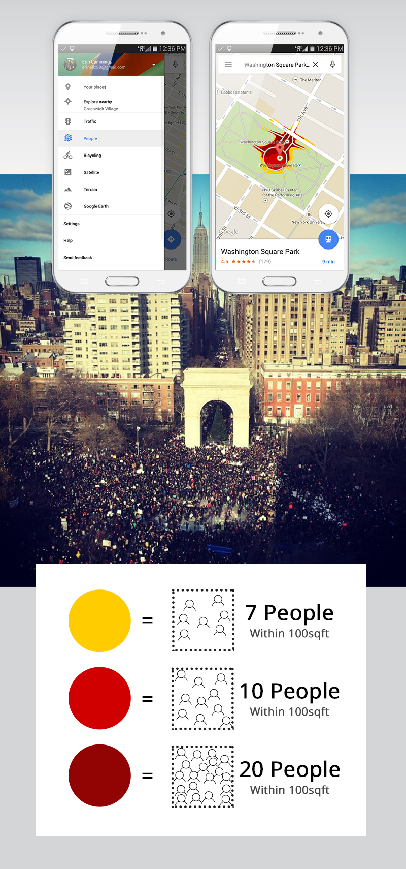
Living in New York, people are often more of a concern to getting around than traffic. I support all reasons to gather, whether it be a protest or just SantaCon, I believe the right to assemble is important to free speech.
That said, knowing where people are congregating can help you better navigate your path for the day. I was in the back of a cab one day wondering if my favorite restaurant was crowded at that moment (they dont take reservations) and if I should try to go by there. That is when the idea of CrowdSwarm was born.
The screens represented here show a protest that took place in Washington Square park late 2014. It interrupted transit, traffic and (you guessed it) walking! If CrowdSwarm was included in your Google map you could have seen what was happening before you even got there.
This idea could be helpful for more than just protests though. What if you could peek at at a concert venue you plan on going at just to see how many people are there now? Or you could zoom in on your favorite mall to see if it is busy?
There are a ton of cool and helpful applications CrowdSwarm could give you.
In case you are not aware, Google maps already uses your location settings on your phone to represent traffic on the map. It uses an algorithm to represent the speed of cars via your phone broadcasting its location. So you, in a way, are already contributing to the data needed for CrowdSwarm. For privacy concerns, I have shown that groups of phones location data will be represented as a mark on the map.